top of page


Services
Ground Scanning 3D Work Areas
We capture high-resolution ground imagery and convert it into centimeter-accurate 3D surfaces that document trenches, grades, and active work zones. This service supports utility alignment documentation, corridor mapping, and pre- and post-construction condition verification.
Applications Include:
Trench and corridor mapping
Utility alignment verification
Pre- and post-work condition capture
Measurement and site verification


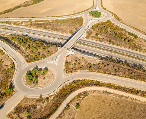
Aerial Mapping
We produce accurate 2D aerial maps and 3D site models using drone photogrammetry to support planning, construction monitoring, and large-area documentation.
Deliverables Include:
Survey-grade orthomosaics ( 2D Maps )
3D site models
Progress comparison maps
Shareable web-based visuals (optional)
Construction Progress & Site Documentation
We provide repeatable drone capture workflows that create consistent visual records for active construction sites. This service supports reporting, verification, and stakeholder communication.
Applications Include:
Progress tracking and verification
Earthwork monitoring
As-built condition capture
Owner and agency reporting support

Pavement & Infrastructure Condition Image Datasets (PCI Support)
We provide high-resolution aerial pavement and infrastructure image datasets in support of PCI (Pavement Condition Index) documentation and roadway condition evaluation workflows. Our structured, repeatable capture processes create consistent visual datasets that help agencies document existing conditions and maintain accurate infrastructure records.
Deliverables Include:
Geo-referenced roadway surface image datasets
High-resolution orthomosaic pavement imagery
Structured visual condition capture for baseline documentation
Repeatable dataset collection for ongoing condition monitoring
Data formatted for integration into existing asset & pavement management systems
bottom of page